Richard S. Hackley: His Ownership and Survey of the Charlotte Harbor area Two Hundred Years
by Graham M. Segger[i]
There were several surveys of Punta Gorda and Charlotte Harbor completed prior to when Isaac Trabue and Albert Gilchrist came to town. Around 1849 John M. Irwin prepared a survey of Hickory Bluff on the north side of the mouth of the Peace River[ii] and between 1859 and 1872 teams led by John Johnson and Samuel Hamblen laid out a survey of Punta Gorda and Alligator Creek[iii]. Not nearly as well known is a much earlier survey of the area which was prepared 200 years ago, just after Florida was purchased from Spain.
On December 17, 1817 King Ferdinand of Spain granted a huge swath of the then Spanish colony of Florida to a favored courtier, the Duke of Alagon[iv]. On May 29, 1819 American citizen Richard Shippey Hackley purchased 12 million acres of this grant from the Duke, extending from Ocala in the north to south of Marco Island. Hackley was a relative through marriage of Thomas Jefferson, who had appointed him as U.S. Consul at Sanlúcar de Barrameda, Spain[v].
After years of negotiations Spain signed a treaty on February 22, 1819[vi] agreeing to sell the colony of Florida to the USA, effective Jan. 28, 1821, in exchange for assuming $5.0 million of debt[vii]. There can be little doubt that the Duke of Alagon was aware of these negotiations and agreements and in all likelihood sold to the well connected U.S. citizen Hackley in order to help shore up support for the title to these lands. Hackley helped fund the purchase by selling various parcels to US investors over the course of the 1820s and 1830s.
Hackley and his family established their own settlement base on the shores of Tampa Bay in 1823. This decision created conflicts with the authorities when in 1824 the U.S. Army decided that the Hackley compound was an ideal location for Fort Brooke, the new military headquarters for Southwest Florida. There are several comprehensive resources available which describe the Hackley Tampa settlement and the disputes over its title[viii].
What ensued was a protracted legal battle between the United States government and Hackley, his investors and his heirs. Hackley had some early successes but the United States government prevailed in 1838. The heirs of Hackley and others who had bought land from him continued with various legal appeals which were not finally settled until 1905 when the Supreme Court ruled against the Appellants[ix]. The basic flaw in Hackley’s claim was that the King of Spain had repudiated the grant to the Duke of Alagon in connection with the sale of Florida to the USA.
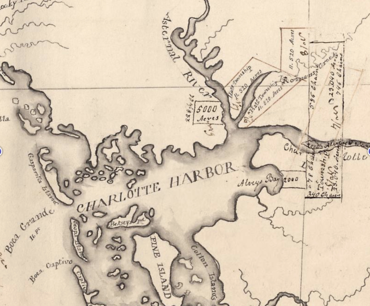
While a book could easily be written on the various legal twists and turns of this land title dispute[x], what is of most interest to the history of Punta Gorda and Charlotte Harbor is a map prepared for Richard S. Hackley in support of his efforts to resell portions of this huge land acquisition. The crop from the “Hackley Lands” map[xi]reproduced below is based upon a map originally compiled and drawn by Charles Vignoles and engraved by H.S. Tanner in 1823[xii]. The Peace River is labeled as the Charlotte River and the Myakka as the Asternal.

The copy of the Hackley map in the Library of Congress, with various township notations, is not dated[xiii] but may have been prepared in support of a Prospectus style document published in 1835[xiv]. Included in the promotional book was a letter from J.H. Randolph to Richard S. Hackley which stated:
“Charlotte Harbor is certainly the most delightful situation on the whole coast of Florida. In beauty of scenery, as well as in salubrity of climate, and quality of soil, no place on the coast can be compared with it.”
Written in the style of the unabashed land sale promoters which they were! This map also had some hand written notes in the margins signed by Richard S. Hackley which extolled the quality of the land.
The Florida “Hackley Land” was south of the boundaries of the 1827 Seminole Reservation established after the conclusion of the First Seminole War, but the townships south and east of Charlotte Harbor and the Peace River overlapped with the land set aside for the Seminole in 1842, after the conclusion of the Second Seminole war.
On June 2, 1832 one of R.S. Hackley’s sons, W. B. R. Hackley, embarked from Key West on a tour of the lands claimed by his father on the west coast of Florida. He was accompanied by Col. George W. Murray and Mr. P. B. Prior. An 1837 publication by John Lee Williams[xv], noted that the expedition passed many keys in Charlotte Harbor which:
“were under cultivation; producing corn, pumpkins, melons, potatoes, various kinds of beans, etc. The lime and cocoa nut trees on Caldes Island (Useppa) looked flourishing”.
The party also rowed up both the Caloosahatchee and Peace (which they called Macaco) Rivers.
The “Hackley Lands” map, reflecting several large tracts of land for sale near Alligator Creek, and straddling both the lower Myakka and Peace Rivers, is the earliest documentation of an attempt to subdivide the lands within what is now Charlotte County. Hackley’s title to the land may have been flawed, but the documents produced in connection with the enterprise provide facsinating insights into the Florida frontier prior to widespread American settlement.
Richard S. Hackley died in a financially ruined state in February 1843.
[i] Graham Segger is the author of Where Do We Live? aka The Burnt Store Road book (www.wheredowelive.com)
[ii] Scot Shively, Hickory Bluff Cemetery: A Charlotte County Pioneer African American Cemetery. Research conducted for the Blanchard House Museum of African American History and Culture of Charlotte County during the period February 2007 through January 2016
[iii] The first comprehensive survey of the Charlotte Harbor east shore in what is now Charlotte and Lee Counties was published by the Surveyor General’s Office, Tallahassee, Florida, July 20, 1872. The surveys were performed by John Jackson in 1859 and updated in 1871 by Samuel Hamblen. Copies of the original township and range maps can be located through http://www.glorecords.blm.gov/search/default.aspx#searchTabIndex=1
[iv] T. Frederick Davis, “The Alagon, Punon Rostro, and Vargas Land Grants, The Florida Historical Quarterly, Vol. 25, No. 2 (Oct., 1946), pp. 175-190 (16 pages)
[v] Sanlúcar de Barrameda is the port at the mouth of the Guadalquivir River which leads from the Atlantic Ocean to Seville.
[vi] The Transcontinental Treaty, also called the Adams-Onis Treaty
[vii] D. Luis de Onís, Memoir upon the negotiations between Spain and the United States of America, which led to the treaty of 1819 with a statistical notice of that country. Accompanied with an appendix, containing important documents for the better illustration of the subject (Madrid, 1820). From the press of D. M. De Burgos. Translated from the Spanish, with notes, by Tobias Watkins. E. de Krafft, Printer, Washington
[viii] Dan O., The Final Battle for Fort Brooke, https://www.tampapix.com/fortbrooke.htm;
Covington, James W. (1980) "The Hackley Grant, The Fort Brooke Military Reservation and Tampa," Sunland Tribune: Vol. 6 , Article 2. Available at: https://digitalcommons.usf.edu/sunlandtribune/vol6/iss1/2
[ix] Sallie Field Scott, Eliza Madison Scott, Harriet B. Jones, et al., Appellants., vs. Lizzie W. Carew, W. W. Hampton, E. R. Gunby, et al, https://openjurist.org/196/us/100
[x] Hackley published Titles and Legal Opinions Thereon, of Lands in East Florida, Belonging to Richard S. Hackley, Esq., (Brooklyn: 1982), printed by G.L. Birch. It provided background on the acquisition and numerous legal opinions supporting his claim.
[xi] Call Number/Physical Location: G3931.G46 1823 .H3, Repository: Library of Congress Geography and Map Division Washington, D.C. 20540-4650, dcuDigital Id: http://hdl.loc.gov/loc.gmd/g3931g.ct000882, Library of Congress Control Number: 2003620010, LCCN Permalink: https://lccn.loc.gov/2003620010
[xii] Call Number/Physical Location: G3930 1823 .V49 TIL, Repository: Library of Congress Geography and Map Division Washington, D.C. 20540-4650, dcu, Digital Id: http://hdl.loc.gov/loc.gmd/g3930.ct000731, Library of Congress Control Number: 2003627045, LCCN Permalink: https://lccn.loc.gov/2003627045
[xiii] Some writers have asserted that the map was created as late as 1904, but this is clearly inaccurate as it has margin notes signed by Richard S. Hackley, who died in 1843
[xiv] Richard S. Hackley, Documents in Proof of the Climate and Soils of Florida, in particular East Florida, (New York: W. Lunt Bradbury, Printer, 1835)
[xv] John Lee Williams, The Territory of Florida: Sketches of the Topography, Civil and Natural History, of the Country, the Climate and the Indian Tribes, from the First Discovery to the Present Time, with a Map, Views, Etc., (New York: A.T. Goodrich, 1837) – p. 289 – Charlotte Harbor at p. 294